Introduction
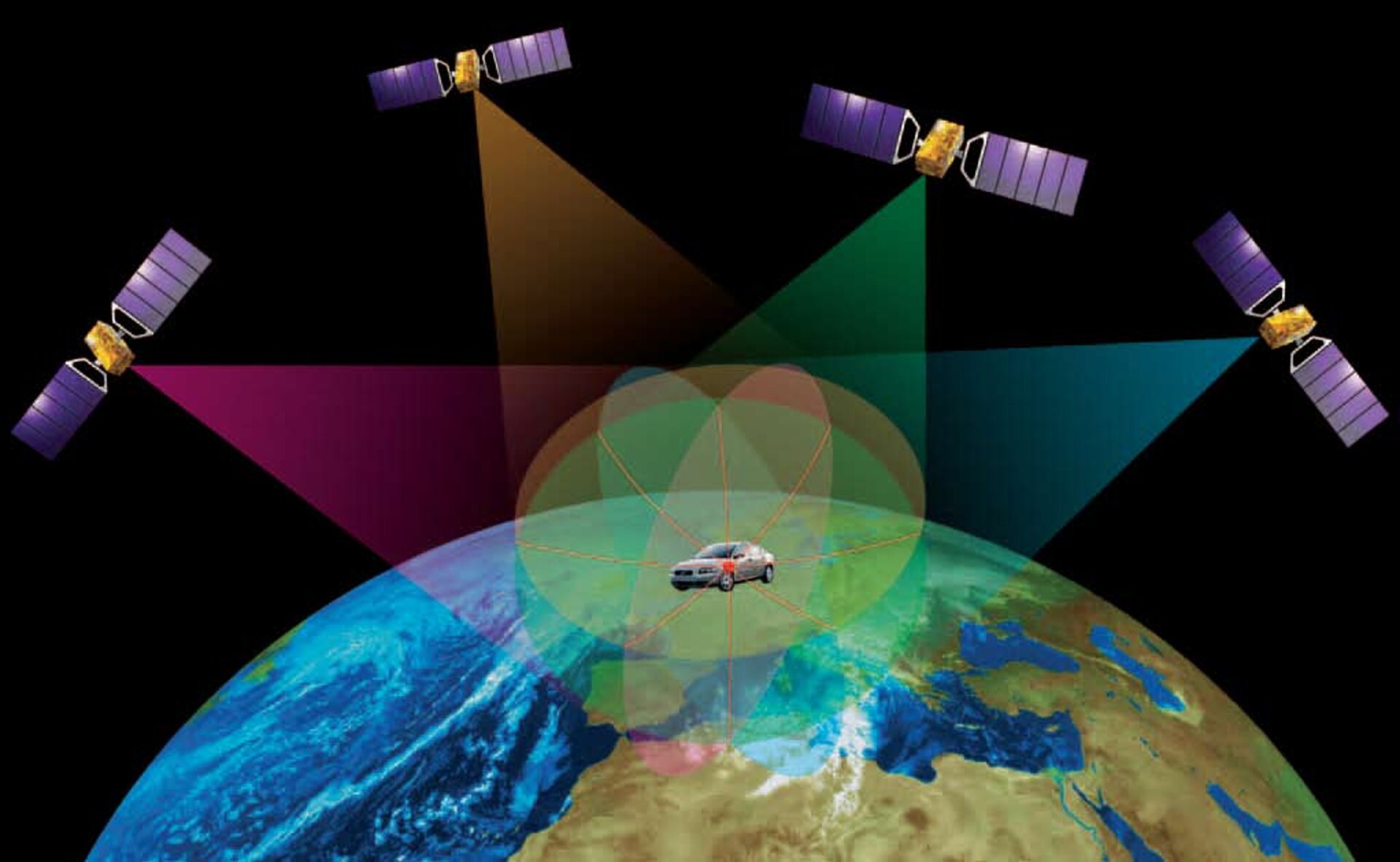
GPS is a global navigation satellite system that provides location and time information to users on Earth. It is a valuable tool for navigation, surveying, tracking, and many other applications. There are several GPS providers that offer different levels of accuracy, availability, and reliability. This review will provide an overview of the major GPS providers, their services, and their respective strengths and weaknesses.
GPS Providers
- NAVSTAR GPS (United States): NAVSTAR GPS is the original GPS system, developed and maintained by the United States Department of Defense. It is the most widely used GPS system in the world, with over 30 satellites in operation. NAVSTAR GPS provides both standard positioning service (SPS) and precise positioning service (PPS). SPS is available to the general public and provides an accuracy of up to 10 meters. PPS is only available to authorized users, such as the military and government agencies, and provides an accuracy of up to 0.1 meters.
- GLONASS (Russia): GLONASS is the Russian equivalent of NAVSTAR GPS. It consists of 24 satellites and provides global coverage. GLONASS is similar to NAVSTAR GPS in terms of accuracy and availability. However, it is not as widely used as NAVSTAR GPS outside of Russia.
- BeiDou (China): BeiDou is the Chinese GPS system, also known as the Compass Navigation System. It is the newest of the major GPS systems and is still under development. BeiDou currently consists of 35 satellites and provides coverage over China and the surrounding region. It is expected to achieve global coverage by 2020.
- Galileo (European Union): Galileo is the European Union’s GPS system. It is still under development and is expected to be fully operational by 2020. Galileo will consist of 30 satellites and will provide global coverage. It is designed to be more accurate and reliable than the other GPS systems.
Strengths and Weaknesses
- NAVSTAR GPS
- Strengths: Widely available, high accuracy, reliable
- Weaknesses: Controlled by the US military, potential for denial of service
- GLONASS
- Strengths: Widely available, high accuracy, reliable
- Weaknesses: Not as widely used as NAVSTAR GPS outside of Russia
- BeiDou
- Strengths: Independent of the US military, high accuracy
- Weaknesses: Still under development, not yet available globally
- Galileo
- Strengths: Designed to be more accurate and reliable than other GPS systems, independent of the US military
- Weaknesses: Still under development, not yet available globally
Conclusion
The choice of GPS provider depends on the specific application and requirements. For applications that require high accuracy and reliability, NAVSTAR GPS or Galileo are the best options. For applications that require global coverage and availability, GLONASS or BeiDou may be better choices. As the GPS systems continue to develop and improve, the accuracy, availability, and reliability of GPS services will continue to increase.# A Review of GPS Providers
Executive Summary
The Global Positioning System (GPS) is a global navigation satellite system that provides location and time information in all weather, anywhere on or near the Earth, where there is an unobstructed line of sight to four or more GPS satellites. The system is maintained by the United States government and is freely accessible to anyone with a GPS receiver.
There are several GPS providers that offer different levels of service, accuracy, and features. Some of the most popular GPS providers include:
- MapQuest
- Waze
- Google Maps
- HERE WeGo
- Garmin
Introduction
GPS has become an essential tool for navigation and location-based services. It is used in everything from smartphones to cars to airplanes. With so many GPS providers to choose from, it can be difficult to know which one is right for you.
In this article, we will review the top 5 GPS providers and compare their features and services. We will also provide a buyer’s guide to help you choose the best GPS provider for your needs.
GPS Provider Comparison
MapQuest
MapQuest is one of the most popular web mapping services in the world. It offers a wide range of features, including turn-by-turn directions, traffic data, and real-time updates.
- MapQuest was launched in 1996 and has been a pioneer in the GPS industry.
- Some of the company’s key features include advanced routing, live traffic updates, and personalized recommendations.
- MapQuest has a comprehensive database of roads and businesses, which allows it to provide accurate and up-to-date directions.
- The user interface is straightforward and easy to use, even for novice users.
Waze
Waze is a crowd-sourced GPS app that offers real-time traffic updates and alerts. It is one of the most popular GPS apps in the world, with over 100 million active users.
- Waze is a community-based navigation app that relies on user input to provide real-time traffic information.
- The app collects data from users’ smartphones and uses it to generate traffic maps and alerts.
- Waze also provides turn-by-turn directions, speed limit alerts, and gas station information.
- The app is free to use and is available for iOS and Android devices.
Google Maps
Google Maps is the most popular GPS app in the world, with over 1 billion active users. It offers a wide range of features, including turn-by-turn directions, traffic data, and real-time updates.
- Google Maps is a comprehensive mapping and navigation tool that offers a variety of features and services.
- The app includes real-time traffic information, turn-by-turn navigation, and satellite imagery.
- Google Maps also allows users to create and share custom maps, and it integrates with other Google products, such as Gmail and Calendar.
- The app is free to use and is available for iOS and Android devices.
HERE WeGo
HERE WeGo is a GPS app that is developed by Nokia. It offers a wide range of features, including turn-by-turn directions, traffic data, and real-time updates.
- HERE WeGo is a mapping and navigation app that offers a variety of features and services.
- The app includes real-time traffic information, turn-by-turn navigation, and public transit directions.
- HERE WeGo also allows users to download maps for offline use, and it offers a variety of customization options.
- The app is free to use and is available for iOS and Android devices.
Garmin
Garmin is a leading manufacturer of GPS devices. Garmin offers a wide range of GPS devices, from entry-level models to high-end models with advanced features.
- Garmin is a well-known brand in the GPS industry, and its products are known for their quality and reliability.
- The company offers a wide range of GPS devices, including handheld GPS units, in-dash car GPS units, and wearable GPS devices.
- Garmin GPS devices typically offer advanced features, such as detailed maps, turn-by-turn directions, and traffic updates.
- Garmin devices are typically more expensive than other GPS devices, but they offer a higher level of performance and reliability.
Conclusion
In this article, we have reviewed the top 5 GPS providers and compared their features and services. We have also provided a buyer’s guide to help you choose the best GPS provider for your needs.
Ultimately, the best GPS provider for you will depend on your specific needs and budget. If you are looking for a basic GPS device for occasional use, then a lower-priced model from a brand like Garmin or Magellan may be a good option. If you are looking for a more advanced GPS device with features like turn-by-turn directions and traffic updates, then you may want to consider a model from a brand like TomTom or Garmin.
Keyword Phrase Tags:
- GPS providers
- GPS comparison
- GPS services
- GPS features
- GPS buyer’s guide
Checkout Tutorialsweb.com for more such articles in the area of Satcom, Software, Networking, Computer Hardware and OS, and Wireless Systems.