Nokia 5G Networking Technology – A Review and Comparison

Networking Technology – A Review and Comparison

In the realm of telecommunications, the advent of 5G technology has ushered in a new era of connectivity, promising good speed, reliability, and capacity. Among the key players in this landscape, Nokia has been at the forefront of developing and implementing 5G networking solutions along with several other players. This article aims to provide a comprehensive review and comparison of Nokia’s 5G networking technology, exploring its features, performance, and market positioning.

Evolution of Nokia’s 5G Networking Technology

Nokia, a renowned name in the telecommunications industry, has been actively involved in shaping the future of 5G technology. The company’s journey in 5G development can be traced back to its early research and standardization efforts. Over the years, Nokia has made significant strides in advancing 5G networking technology, from conceptualization to commercial deployment.

Nokia’s approach to 5G networking encompasses a wide array of technologies, including massive MIMO (Multiple-Input Multiple-Output), beamforming, network slicing, and edge computing. These innovations have enabled Nokia to offer high-speed, low-latency connectivity, catering to diverse use cases ranging from enhanced mobile broadband to mission-critical industrial applications.

Key Features and Capabilities

1. Enhanced Mobile Broadband (eMBB)

Nokia’s 5G networking technology delivers unparalleled speeds, enabling seamless ultra-high-definition video streaming, virtual reality experiences, and immersive gaming. The implementation of massive MIMO and advanced beamforming techniques ensures robust coverage and capacity, enhancing the end-user experience.

2. Ultra-Reliable Low Latency Communication (URLLC)

With a focus on ultra-low latency and high reliability, Nokia’s URLLC capabilities empower critical communication services such as autonomous vehicles, industrial automation, and remote healthcare. By leveraging network slicing and edge computing, Nokia ensures stringent quality of service for latency-sensitive applications.

3. Extensive IoT Connectivity

Nokia’s 5G networking technology provides extensive support for massive IoT deployments, accommodating a vast number of connected devices with varying throughput and latency requirements. This capability is instrumental in enabling the Internet of Things (IoT) ecosystem, spanning smart cities, industrial IoT, and agricultural automation.

Market Comparison and Positioning

Amidst a competitive landscape, Nokia’s 5G networking technology stands out for its comprehensive feature set, interoperability, and scalability. When compared to other industry players, Nokia demonstrates a strong commitment to open standards and interoperability, fostering a multi-vendor ecosystem that promotes innovation and flexibility.

Furthermore, Nokia’s emphasis on end-to-end solutions, spanning radio access, core network, and cloud infrastructure, positions the company as a holistic 5G enabler. This integrated approach resonates with operators and enterprises seeking a unified platform for deploying and managing 5G networks, thereby strengthening Nokia’s foothold in the market.

In conclusion, Nokia’s 5G networking technology represents a culmination of extensive research, innovation, and industry collaboration. With its robust feature set, diverse capabilities, and strategic positioning, Nokia continues to play a pivotal role in shaping the 5G landscape, driving the proliferation of next-generation connectivity across various sectors.

A few disadvantages to be aware of:

  • Limited selection: Compared to other major manufacturers, Nokia currently offers a smaller selection of 5G phones. This means you may have fewer options to choose from in terms of features, price range, and design.
  • Lower-end specs: Many Nokia 5G phones, like the G42 and X30, are positioned in the budget or mid-range segment. This often translates to less powerful processors, lower-resolution displays, and fewer camera features compared to flagship 5G phones from other brands.
  • Slower charging: Some Nokia 5G phones only support slower charging speeds, which means it can take longer to fully recharge the battery compared to phones with faster charging capabilities.
  • Limited 5G band support: Some Nokia 5G phones may have limited support for different 5G bands, which could potentially impact your connection speeds and network compatibility depending on your location and carrier.

Nokia faces competition in the 5G market from several major players, each with their own strengths and weaknesses:

  • Samsung: A leading manufacturer of Android smartphones, Samsung offers a wide range of 5G phones across various price points, from budget-friendly options to high-end flagships like the Galaxy S23 Ultra. They are known for their innovative features, powerful processors, and high-quality displays.

  • Apple: While Apple offers fewer 5G phone models compared to some competitors, their iPhones are known for their premium build quality, powerful A-series processors, and long-lasting software support. The iPhone 15 Pro Max is their current flagship 5G offering.
  • Xiaomi: A popular brand known for offering feature-packed phones at competitive prices, Xiaomi also has a good selection of 5G phones in various segments. Their latest offering is the Xiaomi 13 Pro.
  • Google Pixel: Google’s Pixel series is known for its clean software experience, integration with Google services, and excellent camera capabilities. The Pixel 7 Pro is their latest flagship 5G offering.
  • OnePlus: Another Chinese brand known for its powerful and fast-performing smartphones, OnePlus offers several 5G options, including the recently released OnePlus 11.

These are just a few of the major competitors Nokia faces in the 5G market. When choosing a 5G phone, it’s important to consider your individual needs and preferences, such as budget, desired features, brand preference, and camera quality, to select the best option for you.



NAVSTAR GPS For Commercial Use and It’s Speciafications.

NAVSTAR GPS For Commercial Use and Its Specifications

Introduction

Global Positioning System (GPS) technology has revolutionized the way we navigate and track locations. Originally developed for military use, the NAVSTAR GPS system has since been made available for commercial applications, offering a wide array of specifications that cater to various industries.

Understanding NAVSTAR GPS

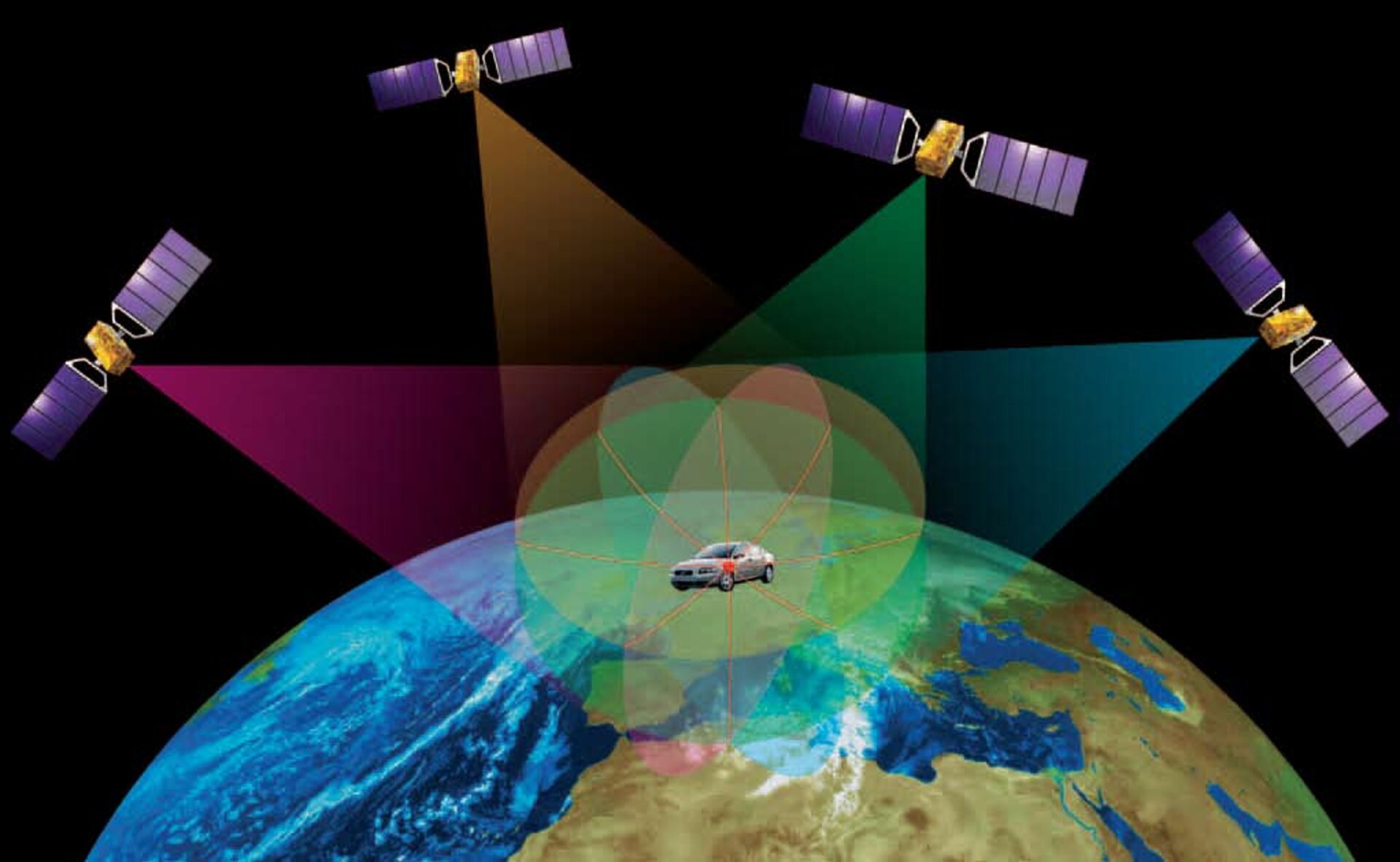
The NAVSTAR GPS, operated by the United States government, consists of a constellation of satellites that provide location and time information anywhere on Earth. This system is widely used in numerous sectors, including transportation, agriculture, surveying, and telecommunications.

Commercial Applications

Transportation Industry

In the transportation sector, NAVSTAR GPS is utilized for vehicle tracking, route optimization, and fleet management. It enables companies to monitor their assets in real-time, leading to improved efficiency and cost savings.

Agriculture

For agricultural purposes, GPS technology assists in precision farming by enabling farmers to map fields, monitor crop health, and optimize irrigation. This results in increased productivity and resource conservation.

Surveying and Mapping

Surveyors and cartographers benefit from the accuracy and reliability of NAVSTAR GPS for creating detailed maps, conducting land surveys, and defining property boundaries with high precision.

Specifications

Accuracy

NAVSTAR GPS offers different levels of accuracy depending on the application. The Standard Positioning Service (SPS) provides an accuracy of approximately 7.8 meters, while the Precise Positioning Service (PPS) can achieve accuracies within centimeters.

Signal Frequency

The system operates using L1 and L2 frequencies, allowing for precise positioning and timing measurements. Dual-frequency receivers are capable of mitigating errors caused by atmospheric disturbances, enhancing overall accuracy.

Availability and Reliability

With a constellation of 24 operational satellites, NAVSTAR GPS ensures global coverage, providing reliable positioning information 24 hours a day, under all weather conditions.

Conclusion

The availability of NAVSTAR GPS for commercial use has significantly impacted various industries, offering unparalleled accuracy, reliability, and global coverage. As technology continues to advance, the integration of GPS into everyday operations will only continue to grow, further enhancing efficiency and productivity across diverse sectors.

A Review of GPS Providers

Introduction

GPS is a global navigation satellite system that provides location and time information to users on Earth. It is a valuable tool for navigation, surveying, tracking, and many other applications. There are several GPS providers that offer different levels of accuracy, availability, and reliability. This review will provide an overview of the major GPS providers, their services, and their respective strengths and weaknesses.

GPS Providers

  • NAVSTAR GPS (United States): NAVSTAR GPS is the original GPS system, developed and maintained by the United States Department of Defense. It is the most widely used GPS system in the world, with over 30 satellites in operation. NAVSTAR GPS provides both standard positioning service (SPS) and precise positioning service (PPS). SPS is available to the general public and provides an accuracy of up to 10 meters. PPS is only available to authorized users, such as the military and government agencies, and provides an accuracy of up to 0.1 meters.
  • GLONASS (Russia): GLONASS is the Russian equivalent of NAVSTAR GPS. It consists of 24 satellites and provides global coverage. GLONASS is similar to NAVSTAR GPS in terms of accuracy and availability. However, it is not as widely used as NAVSTAR GPS outside of Russia.
  • BeiDou (China): BeiDou is the Chinese GPS system, also known as the Compass Navigation System. It is the newest of the major GPS systems and is still under development. BeiDou currently consists of 35 satellites and provides coverage over China and the surrounding region. It is expected to achieve global coverage by 2020.
  • Galileo (European Union): Galileo is the European Union’s GPS system. It is still under development and is expected to be fully operational by 2020. Galileo will consist of 30 satellites and will provide global coverage. It is designed to be more accurate and reliable than the other GPS systems.

Strengths and Weaknesses

  • NAVSTAR GPS
    • Strengths: Widely available, high accuracy, reliable
    • Weaknesses: Controlled by the US military, potential for denial of service
  • GLONASS
    • Strengths: Widely available, high accuracy, reliable
    • Weaknesses: Not as widely used as NAVSTAR GPS outside of Russia
  • BeiDou
    • Strengths: Independent of the US military, high accuracy
    • Weaknesses: Still under development, not yet available globally
  • Galileo
    • Strengths: Designed to be more accurate and reliable than other GPS systems, independent of the US military
    • Weaknesses: Still under development, not yet available globally

Conclusion

The choice of GPS provider depends on the specific application and requirements. For applications that require high accuracy and reliability, NAVSTAR GPS or Galileo are the best options. For applications that require global coverage and availability, GLONASS or BeiDou may be better choices. As the GPS systems continue to develop and improve, the accuracy, availability, and reliability of GPS services will continue to increase.# A Review of GPS Providers

Executive Summary

The Global Positioning System (GPS) is a global navigation satellite system that provides location and time information in all weather, anywhere on or near the Earth, where there is an unobstructed line of sight to four or more GPS satellites. The system is maintained by the United States government and is freely accessible to anyone with a GPS receiver.

There are several GPS providers that offer different levels of service, accuracy, and features. Some of the most popular GPS providers include:

  • MapQuest
  • Waze
  • Google Maps
  • HERE WeGo
  • Garmin

Introduction

GPS has become an essential tool for navigation and location-based services. It is used in everything from smartphones to cars to airplanes. With so many GPS providers to choose from, it can be difficult to know which one is right for you.

In this article, we will review the top 5 GPS providers and compare their features and services. We will also provide a buyer’s guide to help you choose the best GPS provider for your needs.

GPS Provider Comparison

MapQuest

MapQuest is one of the most popular web mapping services in the world. It offers a wide range of features, including turn-by-turn directions, traffic data, and real-time updates.

  • MapQuest was launched in 1996 and has been a pioneer in the GPS industry.
  • Some of the company’s key features include advanced routing, live traffic updates, and personalized recommendations.
  • MapQuest has a comprehensive database of roads and businesses, which allows it to provide accurate and up-to-date directions.
  • The user interface is straightforward and easy to use, even for novice users.

Waze

Waze is a crowd-sourced GPS app that offers real-time traffic updates and alerts. It is one of the most popular GPS apps in the world, with over 100 million active users.

  • Waze is a community-based navigation app that relies on user input to provide real-time traffic information.
  • The app collects data from users’ smartphones and uses it to generate traffic maps and alerts.
  • Waze also provides turn-by-turn directions, speed limit alerts, and gas station information.
  • The app is free to use and is available for iOS and Android devices.

Google Maps

Google Maps is the most popular GPS app in the world, with over 1 billion active users. It offers a wide range of features, including turn-by-turn directions, traffic data, and real-time updates.

  • Google Maps is a comprehensive mapping and navigation tool that offers a variety of features and services.
  • The app includes real-time traffic information, turn-by-turn navigation, and satellite imagery.
  • Google Maps also allows users to create and share custom maps, and it integrates with other Google products, such as Gmail and Calendar.
  • The app is free to use and is available for iOS and Android devices.

HERE WeGo

HERE WeGo is a GPS app that is developed by Nokia. It offers a wide range of features, including turn-by-turn directions, traffic data, and real-time updates.

  • HERE WeGo is a mapping and navigation app that offers a variety of features and services.
  • The app includes real-time traffic information, turn-by-turn navigation, and public transit directions.
  • HERE WeGo also allows users to download maps for offline use, and it offers a variety of customization options.
  • The app is free to use and is available for iOS and Android devices.

Garmin

Garmin is a leading manufacturer of GPS devices. Garmin offers a wide range of GPS devices, from entry-level models to high-end models with advanced features.

  • Garmin is a well-known brand in the GPS industry, and its products are known for their quality and reliability.
  • The company offers a wide range of GPS devices, including handheld GPS units, in-dash car GPS units, and wearable GPS devices.
  • Garmin GPS devices typically offer advanced features, such as detailed maps, turn-by-turn directions, and traffic updates.
  • Garmin devices are typically more expensive than other GPS devices, but they offer a higher level of performance and reliability.


Conclusion

In this article, we have reviewed the top 5 GPS providers and compared their features and services. We have also provided a buyer’s guide to help you choose the best GPS provider for your needs.

Ultimately, the best GPS provider for you will depend on your specific needs and budget. If you are looking for a basic GPS device for occasional use, then a lower-priced model from a brand like Garmin or Magellan may be a good option. If you are looking for a more advanced GPS device with features like turn-by-turn directions and traffic updates, then you may want to consider a model from a brand like TomTom or Garmin.

Keyword Phrase Tags:

  • GPS providers
  • GPS comparison
  • GPS services
  • GPS features
  • GPS buyer’s guide

Checkout Tutorialsweb.com for more such articles in the area of Satcom, Software, Networking, Computer Hardware and OS, and Wireless Systems.

Worldwide GPS Solutions – A Comparison

Worldwide GPS Solutions – A Comparison

The

(GPS) is a global navigation satellite system (GNSS) that provides location and time information in all weather, anywhere on or near the Earth, where there is an unobstructed line of sight to four or more GPS satellites. The system is maintained by the United States government and is freely accessible to anyone with a GPS receiver.

There are a number of different GPS solutions available worldwide, each with its own advantages and disadvantages. Some of the most popular solutions include:

  • Standalone GPS receivers: These are small, portable devices that can be used to determine your location and track your movement. They are typically used for hiking, biking, driving, and other outdoor activities.
  • GPS-enabled smartphones: Many smartphones now come with built-in GPS receivers. This allows you to use your phone to get directions, find nearby businesses, and track your fitness activity.
  • GPS tracking devices: These devices can be attached to vehicles, people, or animals to track their location. They are often used for security, fleet management, and pet tracking.
  • GPS navigation systems: These systems are installed in cars and trucks to provide turn-by-turn directions. They typically include a display screen, a GPS receiver, and a speaker.

The best GPS solution for you will depend on your specific needs. If you only need to use GPS occasionally, a standalone GPS receiver or GPS-enabled smartphone may be all you need. However, if you need to use GPS more frequently, a GPS tracking device or GPS navigation system may be a better option.

Here is a table that compares the different types of GPS solutions:

Type of GPS SolutionAdvantagesDisadvantages
Standalone GPS receiverSmall and portableRequires a clear line of sight to satellites
GPS-enabled smartphoneConvenient and easy to useBattery life can be an issue
GPS tracking deviceCan be used to track vehicles, people, or animalsRequires a subscription
GPS navigation systemProvides turn-by-turn directionsCan be expensive

Conclusion

GPS is a valuable tool that can be used for a variety of purposes. By understanding the different types of GPS solutions available, you can choose the one that best meets your needs.

References: Satellites and Services from Tutorialsweb.com

mmWave 5G Technology Increasing It’s FootPrint!

Ericsson and Airtel showcase mmWave 5G speeds in India: Testing achieved peak speeds of 4.7Gbps, highlighting the potential of mmWave for high-bandwidth applications (RCR Wireless News).

  • Companies: Ericsson, a leading telecom equipment provider, and Bharti Airtel, a major Indian telecom operator, collaborated to demonstrate mmWave 5G functionality on Airtel’s network.
  • Testing: The demonstration achieved peak speeds of 4.7 Gbps, showcasing the immense potential of mmWave technology for high-bandwidth applications.
  • Location: The testing took place in India, a key market for both companies as they explore 5G expansion.
  • Technology: mmWave, or millimeter wave, refers to the high-frequency spectrum (above 24 GHz) used in this demonstration. This spectrum offers ultra-fast data speeds but has limited range and can be blocked by obstacles.

Significance:

  • High-speed potential: Reaching speeds of 4.7 Gbps demonstrates the transformative potential of mmWave for applications like ultra-high-definition video streaming, cloud gaming, and AR/VR experiences.
  • Network capacity: mmWave technology can significantly increase network capacity in densely populated areas, where traditional 5G spectrum might struggle to handle growing demand.
  • Fixed Wireless Access (FWA): The demonstration focused on FWA, where mmWave can deliver broadband internet access to homes and businesses without requiring physical fiber connections. This can be particularly beneficial in areas with limited fiber infrastructure.
  • Emerging market potential: The success in India highlights the potential of mmWave in emerging markets, where fiber infrastructure might be less developed but demand for high-speed connectivity is growing rapidly.

Challenges and considerations:

  • Limited range: mmWave signals have a shorter range than traditional 5G frequencies, requiring more base stations for wider coverage.
  • Infrastructure: Deploying mmWave infrastructure requires significant investment and may face regulatory hurdles in some regions.
  • Device availability: Currently, only a limited number of devices support mmWave connectivity.

Overall, the Ericsson and Airtel showcase showcases the promising potential of mmWave 5G for delivering ultra-fast speeds and increased network capacity, particularly in dense urban areas and emerging markets. However, challenges related to range, infrastructure, and device availability need to be addressed for widespread adoption.

ricsson has implemented mmWave 5G technology in various parts of the world, beyond the collaboration with Airtel in India. Here are some notable examples:

Europe:

  • Germany: Ericsson and O2 Telefónica achieved 4Gbps speeds with mmWave in a Cloud RAN Proof of Concept in Munich.
  • Sweden: Telia Company deployed a mmWave network in Stockholm, reaching speeds of 5 Gbps.
  • Finland: Elisa and Ericsson launched a mmWave pilot in Helsinki, demonstrating applications like virtual reality gaming.

North America:

  • United States: Verizon, AT&T, and T-Mobile have all deployed mmWave networks in major cities, offering significantly faster speeds.
  • Canada: Bell and Rogers have launched limited mmWave deployments in certain cities.

Asia:

  • Japan: NTT Docomo launched a nationwide mmWave network in 2020, aiming for ultra-fast speeds in urban areas.
  • South Korea: SK Telecom and KT Corp. have both deployed mmWave networks in major cities.

Additional points to consider:

  • The specific implementation details of each project vary depending on factors like spectrum availability, infrastructure, and target use cases.
  • Ericsson actively collaborates with various partners to develop and implement mmWave technology globally.
  • While mmWave offers exciting possibilities, it’s important to consider its limitations like shorter range and potential regulatory hurdles in some regions

Does mmWireless Replace Fiber?

It’s unlikely that mmWave 5G will completely replace fiber networks in the foreseeable future. Here’s why:

Strengths and weaknesses of each technology:

  • Fiber:
    • Strengths: Extremely high speeds (up to 100 Gbps), low latency, reliable connection, no range limitations.
    • Weaknesses: High installation cost, limited availability in certain areas.
  • mmWave 5G:
    • Strengths: Very high speeds (up to 10 Gbps), relatively fast deployment, suitable for high-density areas.
    • Weaknesses: Limited range (easily blocked by obstacles), higher network complexity, higher device cost, not yet widely available.

Complementary roles:

Instead of replacing each other, fiber and mmWave 5G are likely to coexist and complement each other:

  • Fiber serves as the backbone: It provides the high-capacity, low-latency connectivity needed to support the massive data demands of 5G networks.
  • mmWave 5G offers additional capacity and speed in specific areas: It can be deployed in densely populated areas, stadiums, airports, etc., to provide ultra-fast speeds for specific uses like VR/AR and high-definition video streaming.

Factors impacting future adoption:

  • Cost: As mmWave technology matures and costs decrease, it might become a more viable option for wider deployment.
  • Infrastructure development: Fiber infrastructure continues to expand, making it a more accessible choice in many regions.
  • User needs: The specific needs and applications will determine which technology is most suitable. For example, fiber might be preferable for home internet, while mmWave could be beneficial for public spaces needing high-speed connectivity.

Conclusion:

While mmWave 5G offers impressive capabilities, it’s unlikely to completely replace fiber networks. They will likely work together to provide a comprehensive and diverse communication infrastructure for the future.

GPS Technologies – Update

Several advancements have occurred in GPS (Global Positioning System) technologies, enhancing accuracy, reliability, and functionality. Here are some of the latest advancements in GPS technologies:

  1. Multi-Constellation and Multi-Frequency GNSS:
    • Integration of signals from multiple satellite constellations (such as GPS, GLONASS, Galileo, and BeiDou) and the use of multiple frequencies improve positioning accuracy and reliability. This multi-constellation, multi-frequency approach helps mitigate signal obstructions and provides better performance in challenging environments.
  2. GPS Augmentation Systems:
    • Augmentation systems like WAAS (Wide Area Augmentation System), EGNOS (European Geostationary Navigation Overlay Service), and others enhance GPS accuracy by correcting errors in satellite signals. These systems are crucial for applications requiring high precision, such as aviation and agriculture.
  3. Real-Time Kinematic (RTK) GPS:
    • RTK GPS provides centimeter-level positioning accuracy in real-time. It involves the use of a base station and a rover, with the base station broadcasting correction signals to improve the accuracy of the rover’s position.
  4. Precise Point Positioning (PPP):
    • PPP is a technique that uses precise satellite orbit and clock information to achieve high-precision positioning without the need for a nearby base station. PPP is valuable for applications requiring accurate positioning globally.
  5. Integration with Other Sensors:
    • GPS is often integrated with other sensors, such as inertial measurement units (IMUs) and accelerometers, to enhance accuracy and maintain positioning in areas with limited or no satellite visibility (e.g., urban canyons, tunnels).
  6. High-Sensitivity GNSS Receivers:
    • Advances in receiver technology have led to high-sensitivity GNSS receivers capable of tracking weaker satellite signals. This improves positioning accuracy in challenging environments like urban areas with tall buildings.
  7. Next-Generation Satellite Constellations:
    • While not fully operational as of my last update, new satellite constellations, such as SpaceX’s Starlink and OneWeb, aim to provide global broadband internet coverage. These constellations may contribute to improved GNSS capabilities in the future.
  8. Galileo and BeiDou Expansions:
    • The Galileo (European Union) and BeiDou (China) satellite constellations have expanded their coverage and capabilities, providing increased global availability of GNSS signals.
  9. GPS in Smartphones and Wearables:
    • Continued integration of GPS in smartphones and wearables has improved location-based services, fitness tracking, and navigation capabilities for consumers.
  10. Autonomous Vehicles and Robotics:
    • GPS is crucial for navigation in autonomous vehicles and robotic systems. Advances in GPS technologies contribute to the development and safety of these technologies.
  11. Crowdsourced GNSS Data:
    • Apps and devices that collect and share GNSS data from users contribute to crowdsourced corrections, improving overall accuracy and reliability in real-world scenarios.

It’s important to note that the field of GPS technologies is dynamic, and ongoing research and innovation are likely to bring further advancements. As technologies evolve, new developments may have occurred since my last update.

Recent Advances in WiFi

Several advancements and developments have taken place in the field of Wi-Fi. Wi-Fi technology continues to evolve to meet the increasing demands for faster speeds, better performance, and enhanced security. Here are some of the latest advances in Wi-Fi technology:

  1. Wi-Fi 6 (802.11ax):
    • Wi-Fi 6 is the latest generation of Wi-Fi technology, officially known as 802.11ax. It brings significant improvements in speed, capacity, and efficiency, making it well-suited for environments with a high density of connected devices. Key features include MU-MIMO (Multi-User, Multiple Input, Multiple Output), OFDMA (Orthogonal Frequency Division Multiple Access), and improved efficiency in handling multiple devices simultaneously.
  2. Wi-Fi 6E:
    • Wi-Fi 6E is an extension of Wi-Fi 6 that introduces support for the 6 GHz frequency band. This additional spectrum provides more available channels and reduces congestion, leading to improved performance and lower latency. Wi-Fi 6E devices can operate in the 2.4 GHz, 5 GHz, and 6 GHz bands.
  3. Increased Data Rates:
    • Wi-Fi 6 and Wi-Fi 6E support higher data rates compared to previous Wi-Fi generations. This is achieved through advancements such as wider channel bandwidths and more advanced modulation schemes.
  4. Orthogonal Frequency Division Multiple Access (OFDMA):
    • OFDMA is a key feature in Wi-Fi 6 that enables the simultaneous transmission of data to multiple devices within the same channel, improving spectrum efficiency and reducing latency.
  5. Improved MU-MIMO:
    • Wi-Fi 6 enhances MU-MIMO capabilities, allowing routers to communicate with multiple devices simultaneously. This is particularly beneficial in environments with numerous connected devices.
  6. Target Wake Time (TWT):
    • TWT is a feature introduced in Wi-Fi 6 that helps extend the battery life of connected devices, such as IoT devices. It allows devices to schedule specific times for communication with the access point, reducing the time the device needs to keep its radio active.
  7. Enhanced Security with WPA3:
    • WPA3 (Wi-Fi Protected Access 3) is the latest security protocol for Wi-Fi networks. It introduces stronger encryption, protection against brute-force attacks, and improved security for open Wi-Fi networks.
  8. AI and Machine Learning Integration:
    • Some Wi-Fi systems incorporate AI and machine learning algorithms to optimize network performance, manage traffic, and adapt to changing conditions dynamically.
  9. Mesh Networking:
    • Mesh Wi-Fi systems have gained popularity, providing improved coverage and reliability by using multiple interconnected access points to create a seamless network.
  10. 6 GHz Band Support for Wi-Fi 7 Development:
    • The Wi-Fi Alliance is working on the development of Wi-Fi 7, which is expected to support the 6 GHz band and bring further enhancements in speed, capacity, and efficiency.

It’s important to note that the Wi-Fi landscape is dynamic, and new developments may have occurred since my last update. The adoption of Wi-Fi 6 and Wi-Fi 6E in consumer devices and networks continues to grow, and ongoing research and innovation in wireless technologies are likely to bring further advancements in the future.

CCNA Certification

The Cisco Certified Network Associate (CCNA) certification is a widely recognized entry-level certification in the field of networking offered by Cisco Systems. The CCNA certification validates the skills and knowledge required to install, configure, operate, and troubleshoot medium-sized routed and switched networks. It is an essential credential for individuals aspiring to pursue a career in networking and serves as a foundational step for more advanced Cisco certifications.

Key Details about CCNA Certification:

  1. Certification Tracks:
    • The CCNA certification underwent a significant update in 2020, consolidating several specialized tracks into a single, comprehensive CCNA.
    • The previous tracks, such as CCNA Routing and Switching, CCNA Security, and others, were merged into the new CCNA.
  2. Prerequisites:
    • There are no formal prerequisites for CCNA. However, having a basic understanding of networking concepts is beneficial.
  3. Exam Details:
    • The CCNA exam (Exam Code: 200-301 CCNA) covers a broad range of topics, including networking fundamentals, network access, IP connectivity, IP services, security fundamentals, and automation and programmability.
    • The exam is conducted at Pearson VUE testing centers.
  4. Exam Format:
    • The exam format includes a mix of multiple-choice questions, drag-and-drop, simulations, and scenario-based questions.
    • The duration of the exam is 120 minutes.
  5. Passing Score:
    • The passing score for the CCNA exam is not pre-determined and is subject to change based on a statistical analysis process.
  6. Recertification:
    • The CCNA certification is valid for three years.
    • Recertification can be achieved by passing the current CCNA exam, a higher-level Cisco certification exam, or a combination of both.

Topics Covered in CCNA Exam (200-301):

  1. Network Fundamentals:
    • Basics of networking concepts, models, and architectures.
  2. Network Access:
    • Ethernet LANs, VLANs, wireless LANs, and various network access security concepts.
  3. IP Connectivity:
    • IP addressing, subnetting, routing, and troubleshooting connectivity issues.
  4. IP Services:
    • DHCP, NAT, NTP, SNMP, and other IP services.
  5. Security Fundamentals:
    • Basic security concepts, such as ACLs, firewalls, and VPNs.
  6. Automation and Programmability:
    • Introduction to network automation, programmability, and basics of Python scripting.

Preparation Resources:

  1. Official Cisco Learning Resources:
    • Cisco provides official study materials, including books, e-learning courses, and practice exams.
  2. Practice Labs:
    • Hands-on labs and simulations are crucial for practical understanding. Cisco offers Packet Tracer and VIRL for virtual lab environments.
  3. Community Support:
    • Engaging with the Cisco community forums and study groups can provide valuable insights and support.
  4. Books and Study Guides:
    • Numerous books and study guides are available from Cisco Press and other publishers.
  5. Training Courses:
    • Instructor-led training courses, both online and in-person, are available from Cisco authorized training centers.

The CCNA certification is highly regarded in the IT industry and serves as a stepping stone for those pursuing more advanced Cisco certifications, such as CCNP and CCIE. It demonstrates a foundational understanding of networking concepts and is relevant for professionals involved in network administration, support, and implementation.